NestScope
W9 2EQ · Neighbourhood Report
© OpenStreetMap · © CARTO
Area Report
Last updated 12 JUN 2026

W9 2EQ

Neighbourhood Report

What's nearby — across walking, short-drive and school catchment distance. Data from official UK government sources.

NestScope Score
64/ 100

An above-average neighbourhood

Anchored on official IMD data — decile 5/10, ranked 13,382 of 32,844 neighbourhoods in England.

How this score is calculated
01 — Snapshot

Around W9 2EQ.

The large figure is how many we found nearby; the chip beside each label is that category’s NestScope score out of 100 — higher beats more of the UK.

Safety45/100
115crimes last month

IMD crime decile 4/10 · 115 crimes in 400m last month (residential-weighted: 65)

Crimes reported last month · UK Police API

Healthcare87/100
79GP & hospitals

IMD health decile 7/10 · 74 GP, 5 hospitals, 68 dentists, pharmacy 0.2 mi within 1.5 mi

Nearest GP: ELGIN CLINIC — 0.3 mi

Transport82/100
Maida Vale Underground Station0.4 mi
Warwick Avenue Underground Station0.4 mi
Warwick Avenue Underground Station0.5 mi

39 bus stops also within 0.5 miles

Green space69/100
35green spaces

IMD environment decile 3/10 · 22.9 ha total — largest park 10.7 ha (0.32 mi away)

Nearest: Bowling Green (0.16 ha) — 0.1 mi

Amenities93/100
97supermarkets

97 supermarkets within 2 mi — Sainsburys, Budgens, The Co-operative Group, Iceland… — nearest 0.2 mi — library 0.1 mi

Nearest: Sainsburys Maida Vale Shirland Road — 0.2 mi

02 — Environment

Environment & risk near W9 2EQ.

Official risk flags for context — deliberately not part of the NestScope score (they’re categorical hazards, not amenities).

Flood risk
Zone 1 (low)

Flood Zone 1 — low risk (less than 1 in 1,000 annual chance) · Source: Environment Agency Flood Map for Planning

Zone 1
Zone 2
Zone 3
Air qualityModerate
21µg/m³

NO₂ annual mean · WHO guideline 10 · UK limit 40 · Source: DEFRA UK-AIR 2024

<10
10–20
20–30
30–40
≥40
Road noiseLoud
66dB Lden

Road traffic, day-evening-night average · Source: DEFRA strategic noise mapping

<55
55–64
65–74
≥75
03 — House prices

Sold prices in W9.

Average sold price by property type across the W9 district, 202120262,438 sales.

£0£5M£10M£15M202120222023202420252026
  • Detached
  • Semi-detached
  • Terraced
  • Flat
Detached£7.1M 259.1%
Semi-detached£8.0M 0.2%
Terraced£2.1M 3.2%
Flat£681k 12.8%

District-level averages (W9) — broad enough to show a reliable trend. A single postcode usually sees too few sales to chart. Source: HM Land Registry Price Paid Data (Crown Copyright / OGL v3.0).

About W9 2EQ

W9 2EQ scores 64/100 on the NestScope Score, with its strongest showing in local amenities and healthcare — with Sainsburys Maida Vale Shirland Road about 5 minutes' walk away. The breakdown below draws on official UK data covering schools, safety, healthcare, transport, environment and local amenities.

In national context, W9 2EQ is an above-average neighbourhood — IMD decile 5/10, ranked 13,382 of 32,844 neighbourhoods in England. The Index of Multiple Deprivation is the UK government's official measure of relative deprivation, refreshed roughly every five years. Housing pressure here is high (IMD housing decile 4/10).

There are 155 schools within the typical catchment area, including 25 rated Outstanding by Ofsted and 57 rated Good. The nearest school is Paddington Academy (Ofsted: Outstanding), within a short walk.

There were 115 crimes reported on the surrounding streets in the most recent month, indicating a high level of immediate-area crime.

Healthcare access is good, with 74 GP surgeries, 5 hospitals and 68 dental practices in the wider neighbourhood. The nearest GP practice is ELGIN CLINIC, about 5 minutes' walk away. The nearest hospital is HOSPITAL OF ST JOHN & ST ELIZABETH, 0.9 mi away. A pharmacy is about 4 minutes' walk away.

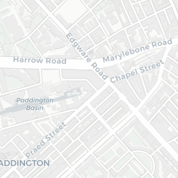
The nearest rail stations are Maida Vale Underground Station (Tube/Metro, about 8 minutes' walk away), Warwick Avenue Underground Station (Tube/Metro, about 8 minutes' walk away), Warwick Avenue Underground Station (Tube/Metro, about 9 minutes' walk away). There are also 39 bus stops within walking distance.

The location is in Flood Zone 1 (low risk — less than a 1 in 1,000 annual chance of river or sea flooding). road traffic noise is high (about 66 dB Lden).

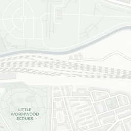
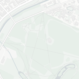
There are 35 green spaces within walking distance, totalling 22.9 hectares of parks and outdoor space. The nearest is Bowling Green (0.16 ha), about 2 minutes' walk away.

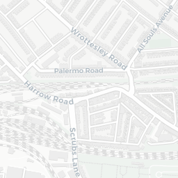
There are 97 supermarkets in the wider area, including Sainsburys, Budgens, The Co-operative Group, Iceland and others. The nearest is Sainsburys Maida Vale Shirland Road, about 5 minutes' walk away. A public library is about 2 minutes' walk away.

Sources: DfE/Ofsted, UK Police API, NHS ODS, NaPTAN, Environment Agency, Ordnance Survey, Natural England, DEFRA, Geolytix and Arts Council England. For an interactive map view, explore W9 2EQ on NestScope.

Explore area insights about nearby locations

Data: DfE/Ofsted · UK Police API · NHS ODS · NaPTAN · Ordnance Survey · Geolytix. Crown Copyright / OGL. Look up any postcode: nestscope.uk/area/YOUR+POSTCODE — e.g. SW1A 1AA, M1 1AE, BS1 1HT.

NestScope

All data from publicly available UK government sources. Each dimension uses a category-appropriate radius (walking distance for crime and transport, school catchment, drive distance for healthcare). IMD context is the latest published English Indices of Deprivation (2019). This report is for informational purposes only.