Nearest top-rated: Lyndhurst Primary School (Good) — 0.1 mi
Safety56/100
—
IMD crime decile 5/10 · live count unavailable
Data temporarily unavailable
Healthcare79/100
49GP & hospitals
IMD health decile 4/10 · 46 GP, 3 hospitals, 42 dentists, pharmacy 0.2 mi within 1.5 mi
Nearest GP: KING'S COLLEGE HOSPITAL UTC — 0.2 mi
Transport75/100
Denmark Hill Rail Station0.1 mi
32 bus stops also within 0.5 miles
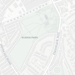
Green space67/100
33green spaces
IMD environment decile 3/10 · 26 ha total — largest park 14.7 ha (0.46 mi away)
Nearest: Sports Facility (700 m²) — 0.1 mi
Amenities90/100
87supermarkets
87 supermarkets within 2 mi — Tesco, Marks and Spencer, Morrisons, Sainsburys… — nearest 0.2 mi — library 0.5 mi
Nearest: Tesco Denmark Hill — 0.2 mi
02 — Environment
Environment & risk near SE5 8RG.
Official risk flags for context — deliberately not part of the NestScope score (they’re categorical hazards, not amenities).
Flood risk
Zone 1 (low)
Flood Zone 1 — low risk (less than 1 in 1,000 annual chance) · Source: Environment Agency Flood Map for Planning
▼
Zone 1
Zone 2
Zone 3
Air qualityModerate
20.6µg/m³
NO₂ annual mean · WHO guideline 10 · UK limit 40 · Source: DEFRA UK-AIR 2024
▼
<10
10–20
20–30
30–40
≥40
Road noiseQuiet
53dB Lden
Road traffic, day-evening-night average · Source: DEFRA strategic noise mapping
▼
<55
55–64
65–74
≥75
Rail noiseQuiet
48dB Lden
Railways, day-evening-night average · Source: DEFRA strategic noise mapping
▼
<55
55–64
65–74
≥75
03 — House prices
Sold prices in SE5.
Average sold price by property type across the SE5 district, 2021–2026 — 2,650 sales.
Detached
Semi-detached
Terraced
Flat
Detached£1.8M▲ 24.7%
Semi-detached£1.4M▲ 27.9%
Terraced£1.4M▲ 22.3%
Flat£441k▲ 0.5%
District-level averages (SE5) — broad enough to show a reliable trend. A single postcode usually sees too few sales to chart. Source: HM Land Registry Price Paid Data (Crown Copyright / OGL v3.0).
About SE5 8RG
SE5 8RG scores 59/100 on the NestScope Score, with its strongest showing in local amenities and healthcare — with Tesco Denmark Hill about 5 minutes' walk away. The breakdown below draws on official UK data covering schools, safety, healthcare, transport, environment and local amenities.
In national context, SE5 8RG is a mixed, mid-ranking neighbourhood — IMD decile 3/10, ranked 9,013 of 32,844 neighbourhoods in England. The Index of Multiple Deprivation is the UK government's official measure of relative deprivation, refreshed roughly every five years. Housing pressure here is high (IMD housing decile 1/10).
There are 138 schools within the typical catchment area, including 23 rated Outstanding by Ofsted and 75 rated Good. The nearest school is Lyndhurst Primary School (Ofsted: Good), about 2 minutes' walk away.
Healthcare access is good, with 46 GP surgeries, 3 hospitals and 42 dental practices in the wider neighbourhood. The nearest GP practice is KING'S COLLEGE HOSPITAL UTC, about 3 minutes' walk away. The nearest hospital is MAUDSLEY HOSPITAL, about 3 minutes' walk away. A pharmacy is about 3 minutes' walk away.
The nearest rail stations are Denmark Hill Rail Station (Train, about 3 minutes' walk away). There are also 32 bus stops within walking distance.
The location is in Flood Zone 1 (low risk — less than a 1 in 1,000 annual chance of river or sea flooding). road traffic noise is low (about 53 dB Lden), and rail noise is low (about 48 dB Lden).
There are 33 green spaces within walking distance, totalling 26 hectares of parks and outdoor space. The nearest is Sports Facility (700 m²), within a short walk.
There are 87 supermarkets in the wider area, including Tesco, Marks and Spencer, Morrisons, Sainsburys and others. The nearest is Tesco Denmark Hill, about 5 minutes' walk away. A public library is about 11 minutes' walk away.
Sources: DfE/Ofsted, UK Police API, NHS ODS, NaPTAN, Environment Agency, Ordnance Survey, Natural England, DEFRA, Geolytix and Arts Council England. For an interactive map view, explore SE5 8RG on NestScope.